Accumulating snow, heavy rainfall and hail all possible in south-central Texas
BEXAR COUNTY (KTSA News) — Some parts of the greater San Antonio area could see some snow. Some will see heavy rain. Some will see some hail.
All three are possible Wednesday night through New Year’s Eve, though the likelihood of which you will see depends on where you are.
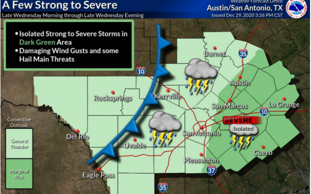
The National Weather Service said the primary issue for the immediate San Antonio area — Bexar County and surrounding counties — will be strong to severe thunderstorms. The greater risk of severe storms will be generally east of San Antonio, east of Pleasanton, and east of the Texas Hill Country.
Areas like San Antonio, Pleasanton, and Uvalde are currently forecast to see an inch to an inch and a half of rain. Bigger rainfall totals are expected to the north and east. San Marcos and Cuero could see up to two inches of rain; Austin could see up to three inches of rain. Damaging winds and some hail are the main hazards in areas near and east of the Interstate 35 and Interstate 37 corridors.
In terms of snow totals, the greatest chance of accumulation will be north and west of Kerrville, with Kerrville potentially seeing less of an inch pile up while Rocksprings could see two to three inches of snow. Areas west of there could see larger totals. A Winter Storm Watch has been issued for Val Verde and Edwards counties.
The National Weather Service said the Austin area could see a changeover from rain to snow during the storms, but none of that snow is expected to stick.

You Might Also Like