Hurricane Ian’s latest: Residents told to act ‘now’ as Florida braces for landfall
(NEW YORK) — Hurricane Ian strengthened into a powerful Category 4 hurricane on Wednesday morning, hours before it was expected to make landfall along Florida’s Gulf Coast.
Landfall is expected between afternoon and early evening in the area near Port Charlotte and Sarasota, though the hurricane’s track, timing and intensity may change.
Florida Gov. Ron DeSantis has declared a state of emergency.
Here’s how the news is developing. All times Eastern:
Sep 28, 5:13 AM EDT
Ian strengthens to Category 4 hurricane
Hurricane Ian strengthened to a Category 4 hurricane on Wednesday morning, as its winds climbed to 140 mph, the National Hurricane Center said.
The storm is the first Category 4 hurricane in the Gulf of Mexico since Hurricane Rita in September 2005.
Sep 28, 3:06 AM EDT
Ian moves closer to Florida’s west coast
Hurricane Ian was moving closer to Florida’s west coast, the National Hurricane Center said in its 2 a.m. ET update on the storm’s position.
The eye of the Category 3 storm was about 95 miles southwest of Naples, Florida, and was moving north-northeast at about 10 mph, officials said.
“On the forecast track, the center of Ian is expected to approach the west coast of Florida within the hurricane warning area this morning, and move onshore later today,” the update said.
Officials said the storm was expected to pass over central Florida on Wednesday night and Thursday morning, before emerging over the Atlantic Ocean late Thursday.
The hurricane was “expected to cause life-threatening storm surge, catastrophic winds and flooding in the Florida peninsula,” the update said.
Sep 28, 2:28 AM EDT
Miami-Dade County suspends transit service
Officials in Miami-Dade County suspended transit services at 1 a.m. ET on Wednesday, as Hurricane Ian approached Florida.
Florida’s most populous county halted its Metrobus, Metrorail, Metromover and Special Transportation Services until further notice, officials said in a news release.
Sep 28, 12:24 AM EDT
DeSantis tells Floridians time to evacuate is ‘now’
Hurricane Ian is fast approaching Florida, and the time to leave is “now” if you’re in an evacuation zone, Gov. Ron DeSantis said late Tuesday during a press conference.
“Your time to evacuate is coming to an end. You need to evacuate now. You’re going to start feeling major impacts of this storm relatively soon,” the governor said. “Now is the time to do it, and now is the time to act.”
As of Tuesday night, about 8,000 people were without power in the southern part of Florida, officials said.
Conditions are expected to continue to deteriorate across central and south Florida, with landfall currently forecast sometime between Wednesday afternoon and early evening.
Elsewhere, a tropical storm warning is now in effect along the coast of Georgia and up to Charleston, S.C.
Sep 27, 10:31 PM EDT
Biden spoke with DeSantis, White House press secretary says
President Joe Biden spoke Tuesday night with Gov. Ron DeSantis ahead of Hurricane Ian’s arrival “to discuss the steps the federal government is taking to help Florida prepare,” White House press secretary Karine Jean-Pierre tweeted.
“The president and the governor committed to continued close coordination,” Jean-Pierre wrote.
Sep 27, 10:18 PM EDT
Cuba without power in wake of Hurricane Ian: Reports
Cuba has lost power after Hurricane Ian made landfall on the island Tuesday, according to reports.
There is “0 electricity generation” in the country, according to a National Electric System update.
“This complicated condition is also associated with complex weather conditions that have affected the SEN infrastructure,” the update said.
Sep 27, 8:33 PM EDT
Some Florida residents begin evacuating ahead of Ian’s landfall
Some Florida residents have begun evacuating their homes as Hurricane Ian approaches.
People are seeking shelter ahead of the storm, which is currently forecast to make landfall as a Category 4 hurricane sometime Wednesday afternoon.
Ian remains a Category 3 storm with maximum sustained winds of 120 mph as of Tuesday might.
It’s moving north-northeast at 10 mph and the center is located about 180 miles south-southwest of Punta Gorda, Florida.
There have been multiple tornado warnings in the area over the past few hours. A large tornado was reported on the ground in southern Broward County, near Davie, at around 7:30 p.m. ET.
Sep 27, 7:34 PM EDT
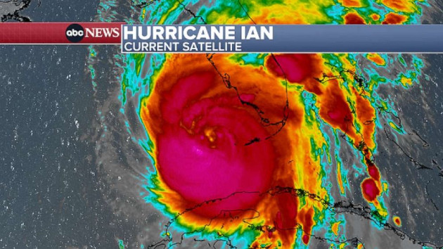
Satellite images show lightning-packed eye of Hurricane Ian
Hurricane Ian is barreling toward Florida, and satellite images show the eye of the storm packed with lightning as it strengthens over the Gulf of Mexico.
The storm is currently forecast to make landfall on Florida’s western coast on Wednesday between 1 and 6 p.m., somewhere between Port Charlotte and Sarasota.
See the latest maps and read more about Hurricane Ian’s projections and possible paths here.
Sep 27, 6:31 PM EDT
DeSantis on Hurricane Ian: ‘This thing is the real deal, it is a major, major storm’
Florida Gov. Ron DeSantis has urged Floridians to take Hurricane Ian seriously as the powerful storm heads to the state.
“You don’t get a mulligan when your personal safety is at risk,” he said during a press conference on Tuesday.
About 2.5 million people in the state are under evacuation orders.
“This thing is the real deal. It is a major, major storm,” DeSantis said.
-ABC News’ Darren Reynolds
Sep 27, 5:43 PM EDT
5,000 Florida Guardsmen activated and prepping for Hurricane Ian
Florida Gov. Ron DeSantis has activated 5,000 Florida National Guardsmen to armories across the state in preparation for Hurricane Ian, which is forecast to hit the state on Wednesday.
Roughly 2,000 National Guard members from neighboring states such as Tennessee are also being activated to assist, the Florida National Guard said in a statement Tuesday.
“The Florida National Guard is well-equipped, with assets including high-wheeled vehicles, helicopters, boats, generators and more,” the statement said.
The U.S. Navy has authorized non-essential personnel in various Florida counties to evacuate.
-ABC News’ Matt Seyler
Sep 27, 5:12 PM EDT
Landfall forecast for Wednesday afternoon or evening
Hurricane Ian, barreling north toward Florida with 120 mph winds, is now located about 230 miles away from Sarasota.
Ian is expected to make landfall in Florida on Wednesday afternoon or early evening.
Ian’s outer bands are already hitting South Florida, bringing a threat of heavy downpours, strong wind gusts, frequent lightning and even tornadoes. A tornado watch is in effect for South Florida until 5 a.m. Wednesday.
-ABC News’ Dan Peck
Sep 27, 4:51 PM EDT
Walt Disney World, Universal Orlando to close
Walt Disney World and Universal Orlando will close Wednesday and Thursday due to the storm.
Sep 27, 3:56 PM EDT
Coastal Georgia, South Carolina under tropical storm watches
As Ian moves north over Florida, tropical storm force winds will reach coastal Georgia and South Carolina.
Tropical storm watches have been issued for Savannah and near Charleston.
Georgia Gov. Brian Kemp has issued a state of emergency.
Sep 27, 2:57 PM EDT
Ian, a Category 3, expected to strengthen more
Ian, now a Category 3 hurricane with 120 mph winds, has strengthened on Tuesday and is forecast to strengthen even more into the night.
People walk through a flooded street in Batabano, Cuba, Sept. 27, 2022, during the…Read More
The latest track shows Ian making landfall on Wednesday, striking the west coast of Florida between Tampa and Fort Myers, bringing flooding and damaging winds.
Hurricane warnings are in effect from Tampa to Fort Myers and storm surge warnings are in effect for a large portion of Florida’s west coast.
There is also a risk for tornadoes in Florida Tuesday and Wednesday.
Sep 27, 2:34 PM EDT
FEMA: ‘Do not underestimate’ Ian
Federal Emergency Management Agency Administrator Deanne Criswell warned Tuesday, “Floridians are going to experience the impacts from the storm for a very long time.”
“Our biggest concern as we wait for this storm to make landfall is storm surge,” Criswell said. “In 2018, when Hurricane Michael impacted the Florida Panhandle, there were five recorded fatalities as a result of storm surge. So therefore, if people are told to evacuate by their local officials, please listen to them. The decision you choose to make may mean the difference between life and death.”
President Joe Biden on Tuesday urged residents to “evacuate when ordered.”
Biden said he spoke to the mayors of Tampa, St. Petersburg and Clearwater Tuesday morning and told them to “contact me directly” for “whatever they need.”
Criswell said a search and rescue coordination group has been activated, including members from FEMA’s urban search and rescue teams, the Coast Guard, the Department of Defense and the Department of the Interior.
The Red Cross has established 29 shelters and is prepared to open 60 more shelters if needed, she said.
Criswell stressed, “To those who may be watching at home, get ready and do not underestimate the potential that the storm can bring.”
Sep 27, 2:28 PM EDT
Orlando’s airport closing Wednesday
The Orlando International Airport said operations will stop at 10:30 a.m. Wednesday.
The St. Pete-Clearwater International Airport is closing at 1 p.m. Tuesday while Tampa International Airport is suspending flights at 5 p.m. Tuesday.
The Sarasota Bradenton International Airport is closing at 8 p.m. Tuesday while the Melbourne Orlando International Airport will stop flights at 2 p.m. Wednesday.
Sep 27, 12:25 PM EDT
Orlando’s airport closing Wednesday
The Orlando International Airport said operations will stop at 10:30 a.m. Wednesday.
The St. Pete-Clearwater International Airport is closing at 1 p.m. Tuesday while Tampa International Airport is suspending flights at 5 p.m. Tuesday.
Sep 27, 12:03 PM EDT
Coastal Georgia, South Carolina under tropical storm watches
As Ian moves north over Florida, tropical storm force winds will reach coastal Georgia and South Carolina.
Tropical storm watches have been issued for Savannah and near Charleston.
Sep 27, 11:13 AM EDT
Landfall in Florida forecast for Wednesday afternoon
Hurricane Ian’s track is moving south, with landfall forecast for late afternoon Wednesday between Tampa and Fort Myers as a Category 3 storm.
The storm surge forecast for Tampa Bay has dropped from 10 feet to 8 feet. But now the predicted storm surge for Fort Myers has increased and could be as high as 12 feet.
Sep 27, 9:41 AM EDT
Tornado watches issued in South Florida
Tornado watches have been issued in Miami, Fort Lauderdale, West Palm Beach, Naples and Key West as Hurricane Ian approaches.
The watches are in effect until 5 p.m. Tuesday.
Sep 27, 8:25 AM EDT
Latest forecast shows landfall in Tampa Bay area
The forecast has shifted significantly east, now with landfall expected in the Tampa Bay area Wednesday night into early Thursday morning as a Category 3 hurricane.
This would mark Tampa Bay’s first direct hit from a major hurricane since 1921.
Slow-moving Ian is expected to drop more than 15 inches of rain from Tampa to Orlando.
Major flooding is possible in Orlando, Tampa and St. Petersburg.
Sep 27, 5:00 AM EDT
Hurricane Ian makes landfall after strengthening to major storm
Hurricane Ian made landfall over western Cuba early on Tuesday morning, the National Hurricane Center said.
“Satellite and radar data indicate that the center of Ian has made landfall just southwest of the town of La Coloma in the Pinar Del Rio Province of Cuba at 4:30 a.m.,” the center said.
Ian’s winds at landfall were estimated at a maximum of 125 mph, making the storm a Category 3 hurricane.
Sep 26, 11:35 PM EDT
Ian strengthens as winds grow to 105 mph
Hurricane Ian continued to intensify Monday night, with maximum sustained winds now at 105 mph.
The hurricane is about 105 miles east-southeast of the western tip of Cuba, which is expected to see significant wind and storm surge impacts soon.
The storm is expected to become a major hurricane overnight or Tuesday morning.
Sep 26, 9:47 PM EDT
Tampa International Airport to close as Ian approaches
Tampa International Airport will stop all operations starting 5 p.m. Tuesday to secure its airfield and terminals ahead of Hurricane Ian’s expected landfall later this week.
Sep 26, 7:14 PM EDT
HHS secretary declares public health emergency for Florida
The U.S. Department of Health and Human Services has declared a public health emergency for the state of Florida.
HHS Secretary Xavier Becerra made the declaration Monday to address the possible health impacts for Florida residents once Hurricane Ian nears the state.
“We will do all we can to assist Florida officials with responding to the health impacts of Hurricane Ian,” Becerra said in a statement. “We are working closely with state, local, and tribal health authorities, as well as our federal partners, and stand ready to provide additional public health and medical support.”
HHS has pre-positioned two 15-person health and medical task force teams from its National Disaster Medical System, as well as a 13-person incident management team and two pharmacists to assist with the response in Florida.
“These teams are highly trained and ready to respond if, when, and where they may be needed following the storm,” HHS Assistant Secretary for Preparedness and Response Dawn O’Connell said.
Florida Gov. Ron DeSantis declared a state of emergency on Saturday. That declaration was approved by President Joe Biden on Sunday.
Sep 26, 6:59 PM EDT
Hurricane warning issued for Tampa Bay area
The National Hurricane Center has issued a hurricane warning for the Tampa Bay area just after its 5 p.m. advisory for Hurricane Ian.
The hurricane, currently a Category 2, is forecast to strengthen before it slows down as it approaches land. It is then expected to hover off the coast of Tampa from Wednesday into Thursday before making landfall.
A hurricane watch has also been issued for Big Bend, Florida, near the panhandle, and tropical storm warnings are in effect for much of southwest Florida.
Tropical storm watches are in effect for Orlando toward the northeast portion of the state, from Fort Pierce to Jacksonville.
-ABC News’ Melissa Griffin
Sep 26, 6:21 PM EDT
Florida utility company to use remote grid technology to restore power during the storm
The emergency response from Florida Power & Light is “well underway” as Hurricane Ian approaches, the utility company announced Monday.
FP&L has mobilized 13,000 workers, as well as supplies, to ensure the response is conducted as safely and quickly as possible after the storm hits, according to a press release.
As the hurricane begins to bear down on the region, FP&L will use remote grid technology to restore power remotely during the storm, as long as it is safe to do so, the company said. After the storm passes and winds drop below 35 mph, FP&L will continue restoration and conduct damage assessments with field crews.
The utility company also urged customers to make preparations and take safety precautions.
“As this storm approaches Florida, we know our customers are counting on us and we are determined to meet this challenge,” said Eric Silagy, chairman and CEO of FP&L in a statement. “We are mobilizing and pre-positioning our restoration workforce, so these brave men and women can quickly start working as soon as it is safe to do so.”
-ABC News’ Matt Foster
Sep 26, 3:58 PM EDT
Florida State University cancels classes
Florida State University has canceled classes Tuesday through Friday as Hurricane Ian approaches.
“The cancellation of classes on Tuesday is to allow students to travel safely out of the area if they so choose,” the university said. “Students who choose to stay in Tallahassee will be advised via the FSU Alert system to follow a ‘shelter in place’ protocol during the storm.”
Sep 26, 3:38 PM EDT
St. Pete-Clearwater International Airport to close
The St. Pete-Clearwater International Airport will close at 1 p.m. Tuesday due to the mandatory evacuation orders in Pinellas County. The airport will stay closed until the evacuation order is lifted.
Sep 26, 2:55 PM EDT
1st mandatory evacuation orders issued
Mandatory evacuation orders are in place for coastal parts of Hillsborough County, Florida. Over 300,000 people are expected to evacuate, officials announced Monday, with emergency shelters opening at 2 p.m. Monday.
Hillsborough County could face up to 15 feet of storm surge and 30 straight hours of tropical storm force winds, Florida Emergency Management Director Tim Dudley said.
County Administrator Bonnie Wise added, “We did not make this decision easily, but the storm poses a serious threat, and we must do everything we can protect our residents.”
Some residents of Sarasota County and Manatee County are also under mandatory evacuation orders.
-ABC News’ Alex Faul
Sep 26, 2:01 PM EDT
7,000 National Guardsmen deployed to help
Five-thousand members of the Florida National Guard have been activated to help during Hurricane Ian. Another 2,000 guardsmen from Tennessee, Georgia and North Carolina are also coming to help, Florida Gov. Ron DeSantis said.
Nearly 300 ambulances and support vehicles are being deployed to areas bracing for Ian’s landfall, DeSantis said.
-ABC News’ Alex Faul
Sep 26, 12:43 PM EDT
Tampa may shut down airport
In Tampa, where residents are bracing for 10 feet of dangerous storm surge, the Tampa International Airport may shut down parts of its airfield and facilities over the next day or two, airport officials announced.
The airport is in an evacuation zone, but because it’s critical infrastructure, it’s “exempt from the storm evacuation order and will stay open until a closure is necessary,” airport officials said in a statement.
It’s been 101 years since Tampa last had a direct hit from a major hurricane.
Sep 26, 11:36 AM EDT
Sarasota, Tampa-area schools close
Hillsborough County Public Schools in Tampa will be closed Monday through Thursday due to the storm. Instead, some schools will operate as storm shelters, the district said.
In Sarasota County, schools will be closed on Tuesday.
Sep 26, 11:34 AM EDT
First mandatory evacuation orders issued
Mandatory evacuation orders are in place for coastal parts of Hillsborough County, Florida. Over 300,000 people are expected to evacuate, officials announced Monday, with emergency shelters opening at 2 p.m. Monday.
Hillsborough County could face up to 15 feet of storm surge and 30 straight hours of tropical storm force winds, Florida Emergency Management Director Tim Dudley said.
County Administrator Bonnie Wise added, “We did not make this decision easily, but the storm poses a serious threat, and we must do everything we can protect our residents.”
Sep 26, 10:43 AM EDT
NASA rolling Artemis rocket back off launch pad
NASA said it will roll the Artemis I rocket off the launch pad and back to the vehicle assembly building on Monday night due to the storm.
“Managers met Monday morning and made the decision based on the latest weather predictions associated with Hurricane Ian, after additional data gathered overnight did not show improving expected conditions for the Kennedy Space Center area,” NASA said in a statement. “The decision allows time for employees to address the needs of their families and protect the integrated rocket and spacecraft system.”
Sep 26, 10:08 AM EDT
Floodwater safety tips to remember
As Ian approaches, here are a few commonsense strategies to help avoid unnecessary risk from floodwaters:
–Before flooding, look up your neighborhood’s flood zone and determine if your home or business is prone to flooding. Come up with an evacuation plan and make sure your car has a full tank of gas. Stock up on non-perishable foods.
–After flooding, ensure your drinking water is sanitized and wash your hands thoroughly after contact with floodwaters. Disinfect objects that have come into contact with floodwater before offering them to children or toddlers.
–Try to avoid exposure with floodwaters for long periods of time to prevent physical injury. Wear waterproof boots if you have them. Do not attempt to drive over flooded streets as it could damage the car and strand passengers.
Sep 26, 10:01 AM EDT
White House closely monitoring Ian
The White House is “closely monitoring” the hurricane, a White House official told ABC News.
President Joe Biden approved Florida’s emergency assistance request this weekend “as soon as he received it,” the official said.
“He also directed his team to surge Federal assistance to the region well before landfall,” the official said. “FEMA has already deployed staff there and pre-positioned food, water, and generators.”
Biden was scheduled to travel to Florida on Monday but that trip has been postponed due to the storm.
-ABC News’ Karen Travers
Sep 26, 8:23 AM EDT
Hurricane watch issued for Tampa, Fort Myers, Naples
Ian is expected to become major Category 3 hurricane Monday night with winds of 115 mph.
As Ian passes Cuba, it’s expected to rapidly intensify, becoming a Category 4 hurricane as it moves through the Gulf. Hurricane warnings are in effect for Cuba and the Cayman Islands.
Models are split when it comes to Ian’s landfall in Florida; impacts could be as far north as Panama City and as far south as Fort Myers.
Some models forecast landfall by Wednesday afternoon between Tampa and Fort Myers, while other models predict landfall at the end of the week near Panama City or Apalachicola.
Hurricane watches have been issued in Tampa, Fort Myers and Naples.
-ABC News’ Max Golembo
Sep 26, 5:20 AM EDT
Storm becomes Hurricane Ian
The National Hurricane Center declared Ian a hurricane on Monday, as the storm gained strength on its way toward Florida.
“A Hurricane Watch has been issued along the west coast of Florida from north of Englewood to the Anclote River, including Tampa Bay,” the center said on Monday.
– ABC News’ Max Golembo
Sep 25, 10:19 PM EDT
NASA to reconvene on whether to take Artemis rocket off launchpad
NASA hasn’t decided whether to leave its Artemis I rocket on the launchpad as it monitors Tropical Storm Ian’s path toward Florida, the agency said Sunday.
The federal space agency’s mission managers will continue discussions on Monday about the next steps as its rocket was delayed again.
On Saturday, NASA scrapped its third planned launch attempt of Artemis I because of weather concerns. Artemis I was scheduled to launch on Sept. 27.
Engineers will decide if the rocket needs to roll back off the launch pad. If they do not roll it back, the next possible launch date is Sunday, Oct. 2.
Tropical Storm Ian is forecast to strengthen into a major hurricane as it nears Florida.
NASA had to scrub the first launch attempt on Aug. 29 because of a faulty temperature sensor and the second attempt on Sept. 3 due to a liquid hydrogen leak.
If the Oct. 2 launch doesn’t happen, the rocket will be taken back to the Vehicle Assembly Building at the Kennedy Space Center until the team decides on the next date.
-ABC News’ Gina Sunseri, Mary Kekatos and Nadine El-Bawab
Sep 25, 10:27 PM EDT
Ian strengthens once again, forecast to become hurricane on Monday
Tropical Storm Ian has strengthened with maximum sustained winds at 60 mph and is expected to get stronger throughout the night as atmospheric conditions become more favorable for the storm.
Ian is forecast to become a hurricane on Monday, becoming even more intense likely into Tuesday.
Ian is moving to the northwest to the Northwest at 12 mph, with the center located 160 miles away from Grand Cayman.
Jamaica and the Cayman Islands are expected to experience heavy rain, a heavy surge and possible flash flooding over the next 24 hours.
-ABC News’ Dan Peck
Sep 25, 5:45 PM EDT
Ian weakens slightly but will regain strength overnight
Tropical Storm Ian has weakened slightly, but it is expected to not only strengthen but rapidly intensify overnight as it travels over warm waters in the Caribbean.
As of 5 p.m. ET, the storm system had maximum sustained winds of 45 mph and was moving west-northwest at 12 mph, with the center located about 220 miles away from Grand Cayman.
Dry air ahead of the storm has delayed the strengthening trend so far. But the rapid intensification is expected to occur Monday into Tuesday as the system continues across the northwestern Caribbean and closes in on western Cuba.
Over the next 24 hours, the outer bands will impact Jamaica and the Cayman Islands, bringing rounds of heavy rain, possible flash flooding and storm surge. Later Monday and into Monday night, Ian will be closing in on western Cuba and will likely bring significant wind and storm surge impacts to the region.
A hurricane warning is in effect for Grand Cayman and portions of western Cuba. A tropical storm watch has been issued for portions of western Cuba, as well as the lower Florida Keys, including Key West.
As of 5 p.m., the forecast track was nudged slightly eastward. Overall, the forecast guidance variability and uncertainty will remain high, and the track for where the storm will be from the middle to the end of the week will continue to shift over the next 24 to 48 hours.
-ABC News’ Dan Peck
Copyright © 2022, ABC Audio. All rights reserved.
You Might Also Like