Storms with potentially large hail possible in western portions of San Antonio area
BEXAR COUNTY (KTSA News) — The whole greater San Antonio region has a chance of seeing severe storms Tuesday night and again late Wednesday, with the greater chance of severe weather being in the western half of the region.
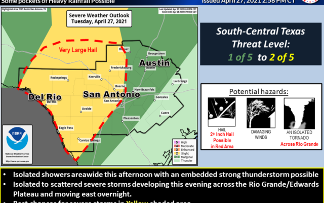
The National Weather Service said Tuesday these storms can bring the chance of very large hail and a large volume of rain.
In an area that covers parts of the region west of U.S. 281 north of San Antonio and Interstate 35 south of San Antonio, the Tuesday night storms have the potential to contain very large hail — more than two inches in diameter, or larger than limes. These storms are expected to be in our area between 9 p.m. Tuesday and 4 a.m. Wednesday. Less than a half inch of rain is expected, though some areas could get up to three inches of rain in localized rainfall.
The second round of storms are expected to impact the greater San Antonio area between 5 p.m. Wednesday and 5 a.m. Thursday. These storms will bring a larger amount of rain, with the general region seeing up to two inches. Some areas, like along the Interstate 35 corridor and areas to the north of San Antonio, could see three to four inches of rain. There is a potential for flooding from this storm.
Both nights of storms have a chance for an isolated tornado.
You Might Also Like