Tropical disturbance in western Gulf could pose threat to parts of US

By Alex Sosnowski, AccuWeather senior meteorologist
A tropical disturbance in the Gulf of Mexico not only has the potential to become the second named storm of the season but even if it fails to organize, it may also cause big problems for already hard-hit flooded areas — depending on the track it takes.
While the risk of development is lower than Monday, down from 60% to 20%, the chance of development will not end until the system moves inland for the final time late this week.
Should the feature reach tropical storm status prior to the end of the week, the next name on the list of tropical storms in the Atlantic basin for the 2019 hurricane season is Barry.

This satellite image was captured on Tuesday, June 4, 2019, and shows the mass of clouds associated with a tropical disturbance over the southwestern Gulf of Mexico. (NOAA)
A general northward drift or wobble of an expanding area of showers and thunderstorms associated with the tropical system is anticipated. The feature is likely to take a curved northward path that bumps and scrapes the western shoreline of the Gulf of Mexico.
This track may unleash heavy rainfall over the lower Mississippi Valley later this week and this weekend.
In terms of development factors, waters are sufficiently warm throughout the western part of the Gulf of Mexico.
Increasing wind shear is forecast as the system moves northward. Low wind shear can allow for tropical development, while higher wind shear can inhibit development.

The exact track and strength of the tropical system will ultimately determine the magnitude and corridor of the heaviest rain. However, a strong and well-organized tropical feature is not necessary for heavy rain and flooding to occur.
“Since the system has failed to become better organized, the heavier rainfall and thunderstorm areas are well removed from the center and mostly to the east of the center as of Tuesday,” according to AccuWeather Hurricane Expert Dan Kottlowski.

“So, despite the center of the system moving near Deep South Texas, the heaviest rainfall will probably stay over the Gulf of Mexico initially, but generally remain east of Deep South Texas through its entirety,” Kottlowski said.
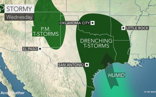
“The heaviest rainfall is likely to occur over eastern Texas on to the north and northeast and into Louisiana.”
“Late this week, moisture from the tropical system is likely to interact with non-tropical features over the southern Plains to generate more heavy rainfall over places that are already experiencing serious flooding.”

A general 1-3 inches of rain can fall on a daily basis in the path of the tropical moisture. The moisture associated with the tropical system can produce a daily AccuWeather Local StormMax™ of 6 inches.
It is possible that some areas along the path of the moisture may receive a foot of rainfall in total over a multiple-day period.
The surge of water moving downstream along the Mississippi River may hit the lower part of the waterway close to the same time as high levels from the Arkansas join in and heavy rainfall from the tropical feature move through late this week and this weekend.
Any heavy rainfall from the lower part of the southern Plains to the middle and lower Mississippi Valley is not welcome at this point. Some rivers have crested at record levels and others are within several feet of record heights.
If tropical moisture becomes fully engaged, several feet of water could be added to some of the already swollen rivers.
You Might Also Like


